
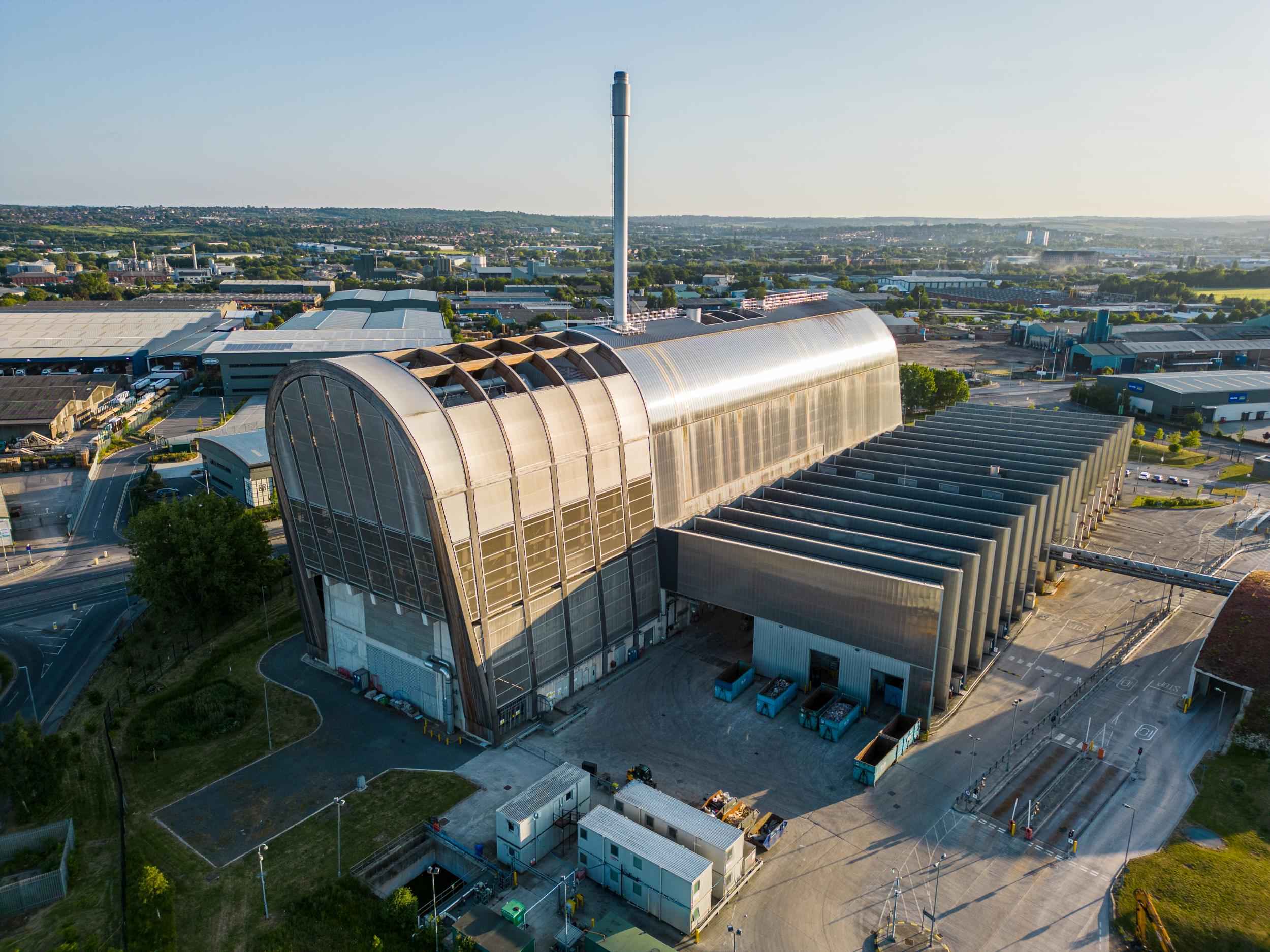
Drone photography on a construction site is aerial documentation — stills and video shot from height to show progress, scale and site layout that a camera at ground level simply can’t fit in the frame.
Ever tried walking a full site with a clipboard and a camera? It’s a slog. And at the end of it you’ve got a folder of shots that each show one corner of the job, and nothing that shows the job. That’s the gap a drone fills.
Quick answer: what are the benefits of drone photography for construction sites?
- Scale and context — a viaduct, a distribution centre or a twenty-acre development doesn’t fit in a ground-level frame.
- Progress documentation — a dated visual record of what the site looked like, and when.
- Site layout — access routes, compound position, laydown areas and how the works sit against what surrounds them.
- Awkward and unsafe areas — roofs, structures and live areas looked at from the air rather than off a ladder or a MEWP.
- Material your team will actually use — bids, case studies, PR, investor and stakeholder updates, recruitment.
What does a drone see that ground photography can’t?
This is the bit worth being precise about, because it’s where most of the value sits. It isn’t that aerial photography is better. It’s that it answers different questions.
| Question | Ground level | From the air |
|---|---|---|
| How big is this job? | Hard to show — no reference for scale | Whole footprint in one frame |
| How is the site laid out? | Only in fragments, walked in sequence | Compound, access, laydown and works in one image |
| What state is the roof or structure in? | Needs access equipment | Shot from a stand-off distance |
| How does it sit in its surroundings? | Blocked by hoarding, plant and buildings | Straightforward |
| What does the workmanship look like close up? | Much better on foot | Not the right tool |
That last row matters. A drone survey of a construction project is a wide-angle answer. The detail — a weld, a splice, a face of brickwork, someone actually doing the work — is still a ground shot, and most sites want both from the same visit.
How often should you shoot a construction site?
Construction companies ask this more than anything else, and the honest answer is that it depends entirely on what the images are for.
| Pattern | Suits | What you end up with |
|---|---|---|
| One-off, near completion | Bids, case studies, website, PR | A finished-project library, no progress story |
| Milestone visits | Progress reporting, client and stakeholder updates | Key stages captured — groundworks, steel, envelope, handover |
| Monthly or fortnightly | Long programmes, funded schemes, time-lapse sequences | A consistent series plus a full documentary record |
If you’re doing repeat visits, the useful trick is flying the same waypoint route each time. The drone takes off, flies an identical path, and shoots from the same positions and heights it did last month. Line those frames up and the build actually appears to grow — which you don’t get from someone eyeballing roughly the same spot each visit.

Can you use drone footage as evidence in a dispute?
Aerial imagery gets used as supporting evidence fairly often, and it’s a decent reason on its own to shoot a site regularly. Every file carries a date and time stamp, and an aerial frame shows the whole site rather than the corner someone chose to photograph.
So when the argument is about what state the ground was in before you started, when a section was actually completed, whether access was blocked, or what was standing on a given date — you’ve got a dated picture instead of a recollection. Same set of images works for investor and stakeholder updates, where people who’ll never set foot on site need to see that things are moving.
Worth being straight about the limit: this is a visual record, not a measured survey. If you need volumes, levels or point-cloud accuracy, that’s a topographic survey firm’s job, not a photographer’s.
What’s actually involved in getting a drone over your site?
Less than people expect, but it isn’t nothing. Here’s the honest version.
- Permissions. The operator needs CAA registration and the right qualification for the flight — I hold a GVC and operate under CAA Operational Authorisation where required, with commercial insurance in place. Every job gets an airspace and restriction check before it’s booked, because plenty of Yorkshire sites sit near airfields, railways or restricted airspace.
- Site paperwork. RAMS, site induction, PPE, and agreement from the principal contractor or landowner to fly over. Handled in advance, same as any other subcontractor.
- Weather. The real constraint. Wind is the usual limiter and most drones aren’t rated for rain. Aerial work gets planned with a fallback date — if conditions are wrong on the day, the flight moves rather than going ahead and producing something flat and grey.
- Time on site. Usually a couple of hours for the aerial element, often combined with ground-level coverage in the same visit.
- Turnaround. Depends on the size of the job and whether there’s video in it. You get a delivery date when you book, and it gets stuck to.
When is a drone not the right answer?
If the job is a small unit, an interior fit-out, or a site where the story is the people and the detail rather than the scale — a drone adds cost and not much else. That conversation is worth having before booking rather than after.
If you’ve got a project that needs showing properly, have a look at how I approach construction and civil engineering photography, or the CAA-authorised drone photography and video side of things. Or just tell me about the project — what stage it’s at, what the images are for, and when the key moments are — and I’ll tell you honestly whether height earns its place on it.
Cheers, Ade
Frequently asked questions
What are the benefits of drone photography for construction sites?
Scale, site layout and context that won’t fit in a ground-level frame, plus a dated visual record of progress and imagery for bids, PR and stakeholder updates. It also lets you look at roofs and awkward areas without access equipment.
Do you need permission to fly a drone over a construction site in the UK?
Yes. The operator needs CAA registration and the right qualification for the flight, plus commercial insurance and an airspace check for that location. You’ll also need the principal contractor or landowner’s agreement, and most sites want RAMS and an induction on top.
How often should you photograph a construction project?
A one-off shoot near completion suits bids and case studies. Milestone visits suit progress reporting. Monthly visits from the same waypoints suit long programmes where you want a consistent sequence at handover.
Can drone footage be used as evidence in a construction dispute?
It’s regularly used as supporting evidence, because each file carries a date and time stamp and shows the whole site rather than a chosen corner. It’s a contemporaneous visual record, not a substitute for a measured survey or a signed instruction.
Can you fly a drone in bad weather?
No. Wind is the usual limiter and most drones aren’t rated for rain. Aerial work is planned with a fallback date, and if conditions are wrong the flight moves rather than producing poor imagery.
Is a drone survey the same as a topographic survey?
No. Drone photography gives you a visual record — images and video. A topographic survey gives measurable data like volumes and levels, and that’s a different specialism with different kit.